
From the Sedona record
When to Hike Devil’s Bridge in Sedona
Devil’s Bridge is one hike with several ways in, so pick yours by your car and the day of the week. In a regular car, park at Dry Creek Vista or Mescal and walk the marked trail; the dirt road to the upper trailhead needs high clearance and is not recommended when wet (Forest Service, read October 5, 2026). From Thursday to Sunday, City of Sedona Shuttle Route 11 stops at Dry Creek Vista and Mescal. Go early, skip hot middays and have a backup hike. The Dry Creek and Mescal trailheads take a Red Rock Pass or America the Beautiful pass; prices are on our Red Rock Pass guide.
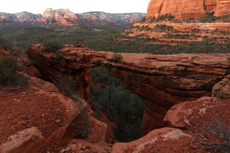

Four ways to reach the bridge
High-clearance FR 152 upper trailhead: unpaved Dry Creek Road (FR 152) to the upper Devil’s Bridge Trailhead; shortest hike to the arch — prefer the USFS Devil’s Bridge #120 page; high-clearance required; not recommended when wet. Dry Creek Vista + Chuckwagon: park at the end of paved Dry Creek Road (Dry Creek Vista); hike Chuckwagon to the bridge — do not walk the unpaved jeep road. Mescal + Chuckwagon: paved Long Canyon Road to Mescal Trailhead; Mescal–Chuckwagon connection to the bridge — standing passenger-car tip. Sedona Shuttle Route 11: City of Sedona public transit: West SR-89A Park & Ride → Dry Creek Vista → Mescal — Thursday–Sunday on the published grid; verify clocks live the morning of on sedonashuttle.com/routes/route-11/. For map and stats, see Devil’s Bridge Trail and Mescal Trail.
Trail facts (USFS Devil’s Bridge Trail No. 120)
Prefer the Forest Service page for trail facts. From Devil’s Bridge Trail No. 120 (read October 5, 2026 PT): largest natural sandstone arch in the Sedona area; difficulty Moderate; trailhead elevation about 4,605 ft; elevation gain 371 ft; length from the upper Devil’s Bridge trailhead 1.6 miles roundtrip; time about 2 hours; via Chuckwagon from Dry Creek Vista adds 2.1 miles one-way — about 2.9 miles one-way / 5.8 miles roundtrip to the bridge; well marked — do not walk the unpaved jeep road; via Mescal–Chuckwagon connection 4.0 miles roundtrip to the bridge. Directions (USFS page): Dry Creek Road (FR 152); right fork onto unpaved; rough; high-clearance required; not recommended when wet; about 1.3 miles then right to the Devil’s Bridge Trailhead. Passenger-vehicle note (USFS page): unpaved FR 152 needs high-clearance. Low-clearance options on the same page: park at Dry Creek Vista (end of paved) or Mescal on Long Canyon Road. Via Mescal directions on the page: Dry Creek Road to Long Canyon Road stop, right 0.2 mile to Mescal Trailhead. Visitor-center contact / hours appear on the USFS page; check them before you go; this page does not add holiday exceptions beyond what the page prints. Official sources can disagree slightly on approach mileage — prefer USFS for trail facts, sedonashuttle.com for Route 11.
Timing (sunrise / pre-shuttle / weekday vs Thu–Sun)
Travellers talk about sunrise starts, arriving before shuttle service, weekday vs shuttle-day windows, and whether a car parked early may leave after shuttle hours begin. This page does not state lot-fill clocks, photo-line minutes, overnight lot-open guarantees, shoulder parking on Dry Creek Road or Long Canyon Road, or tow / citation promises. Confirm trailhead and shuttle rules on the USFS trail page and Route 11 the morning of. Have a backup hike if parking is jammed or the arch is packed. Weekday vs Thursday–Sunday matters because Route 11’s published grid is Thu–Sun only. A Tuesday start is a different plan; check the schedule before you go; daily shuttle service is not assumed here. Expect crowds at peak; go early or pick a quieter option (Airport Mesa · West Fork · Chapel · trip-shape). Never hard-code a photo-line start time as an Index fact. Season / crowd tradeoffs: best time to visit Sedona. Holiday stack: Thanksgiving in Sedona and Christmas in Sedona. Day pacing when stacking Bell / Cathedral / Devil’s: Plan a Sedona trip.
FR 152 is not a passenger-car default
Unpaved FR 152 is a popular jeep road. USFS (read October 5, 2026 PT): rough; high-clearance required; not recommended when wet. Rental / clearance asks are common: verify on the USFS trail page; with a low-clearance rental, skip the dirt road. Do not walk the unpaved jeep road. USFS steers pedestrians to Chuckwagon from Dry Creek Vista or Mescal–Chuckwagon instead. On foot from Dry Creek Vista, take the marked trail — not the dirt road cars use. Light jeep vs DIY: How bumpy are Sedona jeep tours? No jeep-shop picks, unofficial shuttle brands, Uber guarantees, or shoulder-parking advice.
Mescal: paved-lot tip, longer round trip
Mescal is the standing traveller tip for passenger cars and for avoiding FR 152. USFS page (read October 5, 2026 PT): Dry Creek Road to Long Canyon Road stop, right 0.2 mile to Mescal Trailhead; Mescal–Chuckwagon connection; 4.0 miles roundtrip to the bridge — longer than the upper trailhead’s 1.6 miles, but off the jeep road. Confirm Mescal approach and miles on the USFS page the morning you go. For map and stats: Mescal Trail. Families and dogs: Sedona with kids and Sedona with dogs.
Sedona Shuttle Route 11 (Dry Creek Vista / Mescal)
Route 11 is the official City of Sedona public-transit option for this hike — not an unofficial pickup brand. From sedonashuttle.com/routes/route-11/ (read October 5, 2026 PT): service days Thursday – Sunday only (published grid); stops West SR-89A Park & Ride → Dry Creek Vista → Mescal; first outbound AM 7:00 / last out 4:30 on page; return has a late ~5:20* note (Mescal before Dry Creek on the return); footer Effective November 6, 2023 — check clocks live; they are not permanent; page notes additional trips to Dry Creek Vista Trailhead on Route 12 — check live; Route 12 is not treated here as a Mescal substitute. Re-check Route 11 the morning of. Seasonal / heat-reduction schedule changes have happened historically — clocks here are a dated reading, not permanent. This page does not assume daily service or name unofficial shuttle brands. A secondary pointer: hiking ideas from Sedona Shuttle stops on sedonashuttle.com — re-check; prefer USFS for trail miles.
Pass confusion (RRP ≠ ATB ≠ Hospitality)
Mixing them in one breath is the common traveller mistake this section answers. Red Rock Pass (USDA Forest Service / Coconino NF): many Sedona-area National Forest fee sites. America the Beautiful (interagency pass): can stand in for Red Rock Pass at many Coconino NF fee sites. Coconino Hospitality (concessionaire sites, e.g. West Fork / Call of the Canyon): not needed for this hike — keep distinct from RRP / ATB. From the Red Rock & Coconino Passes Program page (read October 5, 2026 PT): Mescal Trailhead = Red Rock Pass or America the Beautiful; Dry Creek Trailhead = Red Rock Pass or America the Beautiful. For the upper FR 152 Devil’s Bridge lot: this page does not claim that lot is or is not on the Passes Program list when it is not named for your exact lot — : confirm the lot you actually use on the Passes Program page the morning you go. Pass prices, dated, are on the Red Rock Pass guide. To buy online: Recreation.gov Red Rock Pass sitepass. Hospitality day-use for West Fork is a different pass: see West Fork Trail / Call of the Canyon. Pass / day pacing when stacking Devil’s Bridge + other stops: Plan a Sedona trip.
Peak and mid-March crowds
Devil’s Bridge remains a year-round must-do magnet. Around mid-March, spring break and other peaks, travellers report long waits when the day is busy. Expect crowds at peak; arrive with a plan and a backup hike; a forum report of a line at a given time is not a schedule. Quieter-day alternatives: Airport Mesa, West Fork, Chapel of the Holy Cross, Slide Rock State Park, best time to visit Sedona, and Plan a Sedona trip. Closures / fire-season questions appear in threads — current open/closed status is not stated here. Check Coconino alerts and the USFS Devil’s Bridge page before you drive.
Heat and exposure
Approaches are exposed red rock. Hot midday is a poor default — see cool things to do on a hot day in Sedona. No medical or fitness advice here. City of Sedona has historically adjusted Route 11 for heat / rescue volume — another reason to check Route 11 clocks live on a summer morning rather than rely on this dated reading.
If you want a different shape of day
Sunrise / sunset parking alternative: Airport Mesa. Landmark without FR 152: Chapel of the Holy Cross. Creek / canyon: Slide Rock State Park and West Fork Trail / Call of the Canyon. Season / pacing: best time to visit Sedona and Plan a Sedona trip. Hot midday: cool things to do on a hot day in Sedona. Kids / dogs: Sedona with kids and Sedona with dogs. Light jeep vs DIY: How bumpy are Sedona jeep tours? Vortex sites: Do you need a guide for Sedona vortex sites? Views without FR 152: Airport Loop Trail.
- Airport Mesa / Airport Scenic Overlook / Airport Loop
- Chapel of the Holy Cross (Sedona)
- Slide Rock State Park (Sedona / Oak Creek Canyon)
- West Fork Trail / Call of the Canyon (Sedona / Oak Creek Canyon)
- Best time to visit Sedona
- Plan a Sedona trip
- Cool things to do on a hot day in Sedona, Arizona
- Sedona with kids under about ten
- Sedona with dogs
- How bumpy are Sedona jeep tours — and which ones are gentle?
- Do you need a guide for Sedona vortex sites?
- Airport Loop Trail
Next steps
Decide first: high-clearance FR 152 upper trailhead, Dry Creek Vista + Chuckwagon, Mescal + Chuckwagon, or Route 11 — the right choice follows vehicle and day-of-week. Check the Forest Service Devil’s Bridge Trail No. 120 page before you drive. Need the shuttle? Open Route 11 the morning of — Thu–Sun published grid; check clocks live (the timetable footer read Effective November 6, 2023). Confirm which pass applies to your lot — Mescal and Dry Creek need Red Rock Pass or America the Beautiful per the Passes Program page; re-check the Passes Program page. Do not walk the unpaved jeep road — use Chuckwagon / Mescal per USFS. Low-clearance rental? A good default is Mescal, Dry Creek Vista + trail, or Route 11 on a published service day. Hot midday? Leave the arch for cooler hours and use the hot-day guide. No medical advice here. For map and stats, see the Devil’s Bridge Trail and Mescal Trail pages. Alternative days: Airport Mesa, Chapel, Slide Rock, West Fork, trip-shape, and best time. Have a backup if the bridge is packed. Corrections are free and need no account.
What this page will not say
It does not state lot-fill clocks, photo-line minutes, space counts, overnight lot guarantees, shoulder-parking advice, or tow / citation rules. It does not assume daily Route 11 service or unofficial shuttle brands. It does not state an upper FR 152 lot fee row if that lot is unnamed on the Passes Program page. It will not mix Red Rock Pass, America the Beautiful, and Coconino Hospitality as if interchangeable. It will not name lodging, restaurants, jeep shops, or Uber guarantees. It will not give medical or fitness advice, rank a best arch, deep-link a car-free guide. Fee, trail, and shuttle figures are dated from the official pages; if those pages change, trust those pages.
About this page
This page covers visit logistics from the Forest Service Devil’s Bridge Trail No. 120 page, Sedona Shuttle Route 11, and the Red Rock & Coconino Passes Program page, not lodging or restaurants. Every dated trail figure, shuttle clock, and pass amount below was read from those pages on October 5, 2026; check them the morning you go. It does not state lot-fill clocks, photo-line minutes, tow rules, or unofficial shuttle brands. For map and stats, see Devil’s Bridge Trail and Mescal Trail. Devil’s Bridge is one hike with three access routes plus a shuttle option. The bridge itself does not change — what changes is how you get there: high-clearance up unpaved Forest Road 152 to the upper trailhead, a longer trail approach from Dry Creek Vista via Chuckwagon, a paved-lot Mescal approach that also joins Chuckwagon, or City of Sedona Shuttle Route 11 to Dry Creek Vista / Mescal on published Thursday–Sunday service. Decide vehicle clearance and day-of-week before you leave the hotel. A passenger-car rental and a Friday morning call for a different plan than a high-clearance jeep and a Tuesday. Open the Forest Service Devil’s Bridge Trail No. 120 page and Sedona Shuttle Route 11 the morning you go. Check the official pages before you go; this page is not a gate receipt. Timing is the #1 question — sunrise starts, pre-shuttle parking, weekday vs Thu–Sun shuttle days, mid-March / peak photo waits. Arrive with a plan and a backup hike if the bridge is a zoo. The dated counts this page can honestly print are jeep, trolley and trail records this index already holds for a Sedona day — they are not Red Rock Pass amounts or Route 11 clocks: As of October 5, 2026 that is 24 trail records, 6 jeep tour records and 2 trolley tour records. The comparison pages below are the lists.
What this index currently holds
- Trails
- 24 trail recordsChecked via: Count of compiled, non-sample records in this index
- as of October 5, 2026
- Jeep tour
- 6 jeep tour recordsChecked via: Count of compiled, non-sample records in this index
- as of October 5, 2026
- Trolley tour
- 2 trolley tour recordsChecked via: Count of compiled, non-sample records in this index
- as of October 5, 2026
- Last reviewed
- October 5, 2026
- as of October 5, 2026
Related reading
More long-form answers and the comparison pages this page points at. Figures on those pages come from the records, not from this map. The full shelf is on guides; the compact list is on traveller questions.
Question
How bumpy are Sedona jeep tours — and which ones are gentle?
For travellers with back problems or a low appetite for jostling: which Sedona tours the operators themselves describe as paved, who a jeep is worth it for, and how to read operator health language — no Index medical clearance.
Last reviewed September 28, 2026.
Question
Do you need a guide for Sedona vortex sites?
No — you don't need a guide for the classic Sedona sites travellers call vortexes. Visit Sedona says everyone is welcome to visit on their own; guided tours sell interpretation and transport, not exclusive access. Dated catalog below.
Last reviewed October 16, 2026.
Guide
Best time to visit Sedona
Best time to visit Sedona depends on the priority: spring or fall for hiking comfort and more crowds, or winter chill and summer heat with a dawn plan for quieter days. Weekdays beat weekends; peak lots fill early. No climate normals, lodging rates, or festival dates.
Last reviewed October 9, 2026.
Guide
Airport Mesa / Airport Scenic Overlook / Airport Loop (Sedona)
Airport Mesa is three stops: the drive-up Scenic Overlook, a short vortex/mesa walk, and Airport Loop Trail No. 210. Overlook parking is not a Red Rock Pass or America the Beautiful. Prefer USFS 3.5 mi for the loop; check overlook fees before you go.
Last reviewed October 16, 2026.
Guide
West Fork Trail / Call of the Canyon (Sedona / Oak Creek Canyon)
West Fork Trail No. 108 is under a Forest Service closure order through Oct 31, 2026, unless rescinded; read the closure note before you go. The trail starts at Call of the Canyon on SR 89A, a Coconino Hospitality fee site, not a Red Rock Pass or Slide Rock fee. Check hours and fees on USFS before you go.
Last reviewed October 9, 2026.
Guide
Cool things to do on a hot day in Sedona, Arizona
What to do when Sedona is hot: walk early, then spend the afternoon indoors or in a seat. Counts from this index — trails, jeep and trolley tours, restaurants, coffee, chocolate, tasting rooms, yoga and day spas — dated, not ranked.
Last reviewed September 13, 2026.
Guide
Thanksgiving in Sedona, Arizona
Thanksgiving week in Sedona, checked October 16, 2026: the Sedona Shuttle lists daily service Nov 19–29 except Thanksgiving Day, and the Uptown Visitor Center and Tlaquepaque print Thanksgiving Day closures. Dated trail and scenic counts, not a restaurant list.
Last reviewed October 16, 2026.
Guide
Christmas in Sedona
Christmas and New Year's weeks in Sedona, checked October 16, 2026: the Sedona Shuttle lists daily service Dec 17–24 and service Dec 26–31, none on Christmas Day; the Visitor Center, Tlaquepaque and Red Rock State Park print Christmas Day closures. No restaurant list.
Last reviewed October 16, 2026.
Guide
Sedona with kids under about ten
With children under about ten, start with Slide Rock when the park is open, an easy Forest Service walk, a trolley, or a mild paved scenic jeep. Dated trail and tour counts — no guessed shop, fare or creek claim.
Last reviewed October 16, 2026.
Guide
Sedona with dogs
Yes — you can visit Sedona with a dog if you follow leash and cleanup rules and skip parks that ban pets. Dated trail and jeep counts — no made-up hotel, patio or pet policy.
Last reviewed September 18, 2026.
Guide
Slide Rock State Park (Sedona / Oak Creek Canyon)
Slide Rock State Park: arrive near opening, pay the state-park fee (a Red Rock Pass does not cover it), and confirm hours and water banners live.
Last reviewed September 28, 2026.
Guide
Chapel of the Holy Cross (Sedona)
Chapel of the Holy Cross visit logistics: hours and last entry, limited parking, steep approach, golf-cart assist when available, silence, pets outside.
Last reviewed September 25, 2026.
Compare
Plan a Sedona trip
Plan a Sedona trip: 2 days for an overview plus a hike or jeep, 3 if you add Grand Canyon. Red Rock Pass, stay zones, what to book first, and dated jeep and trolley listings. No booking, no ranking.
Last reviewed October 9, 2026.
Report an error
Found something wrong or out of date? Tell us and we will check it. It is free, there is no account, and you do not have to be the business owner. Corrections go to Thomas Karl at thomas@sedonatechsolutions.com.
Email a correction about When to Hike Devil’s Bridge in Sedona
Opens your email app with the page and a few prompts already filled in. Prefer to write it yourself? Write to thomas@sedonatechsolutions.com directly.