
From the Sedona record
Brins Mesa, Sedona
Brins Mesa Trail No. 119, near Sedona, climbs onto an open mesa with wide red-rock views. The Forest Service rates it Easy to moderate, 3.5 miles and 1 hour 45 minutes one way (read October 9, 2026), so double both for the round trip. The Jim Thompson Trailhead off Jordan Road is the passenger-car start, which the Forest Service calls passable by passenger cars; the Forest Road 152 end needs a high-clearance vehicle or a 2.24-mile road walk. There is little shade, so start early in warm months and carry plenty of water. Parking at Jim Thompson needs a Red Rock Pass or America the Beautiful pass; prices are on our Red Rock Pass guide.

Brins Mesa Trail No. 119: what the Forest Service says
Everything in this table was read from the Forest Service Brins Mesa Trail No. 119 page (https://www.fs.usda.gov/r03/coconino/recreation/trails/brins-mesa-trail-no-119) on October 9, 2026. The page footer says "Last updated July 22, 2025." Trail: Brins Mesa Trail No. 119, Standard/Terra Trail. Managed by: Coconino National Forest (USDA Forest Service). Difficulty: Easy to moderate. Trailhead elevation: 4,632 ft. Elevation gain: 649 ft. Length: 3.5 miles one way. Time: 1 hour 45 mins one way. Parking pass: Red Rock Pass or America the Beautiful Pass required to park at the Jim Thompson trailhead. Restrictions: "No mechanized vehicles (including mountain bikes) in Wilderness." Location: "28 miles south of Flagstaff (1 miles north of Sedona) on paved and dirt Forest roads in scenic red rock country". Wilderness: Listed in the Red Rock–Secret Mountain Wilderness recreation group. Recreation listed: Hiking, horseback riding, viewing scenery and viewing plants. Two numbers are worth reading twice. The length and the time are both one way. If you walk the whole trail and come back the same way, you're doubling both, so plan the day around the round trip, not the headline figure. We don't add a pace of our own, and we don't split the trail into mile markers the Forest Service doesn't print. For the coordinates and the short record of these facts, the Index keeps a trail page: Brins Mesa Trail No. 119. That record was compiled from the same Forest Service page on August 30, 2026, and its distance, gain, difficulty and pass line match what we read on October 9. Use it for the quick numbers. This guide is the place for the questions around the hike.
Two ends, one trail
Brins Mesa Trail has a trailhead at each end, and the Forest Service treats them as two ways onto the same walk: "An alternate approach to the Brins Mesa Trail is to start from the Jim Thompson Trailhead and hike it from that end — same trail, same great views." Here is how the two ends compare, using only the Forest Service's own directions (read October 9, 2026). Getting there, as published — Jim Thompson Trailhead (Jordan Road end): From Flagstaff, south on SR 89A into Sedona, then "turn west (right) on Jordan road. Follow it about a mile to the trailhead."; Brins Mesa Trailhead (FR 152 end): From the "Y" of SR 89A and SR 179, west on 89A to Dry Creek Road, north on Dry Creek Road, then right onto Forest Road 152 to a lower parking lot. Road, as published — Jim Thompson Trailhead (Jordan Road end): "The last 1/4 mile of Jordan Road can be a bit rough, but passable by passenger cars."; Brins Mesa Trailhead (FR 152 end): From the lower lot you can hike another 2.24 miles up FR 152 to the trailhead, or drive it only with a high-clearance vehicle; the Forest Service says that section is not passable for passenger vehicles. Pass, as published — Jim Thompson Trailhead (Jordan Road end): Red Rock Pass or America the Beautiful Pass required to park; Brins Mesa Trailhead (FR 152 end): Not stated on the Brins Mesa page, and the FR 152 end isn't a row on the Passes Program table we read. We don't guess either way. Other facilities — Jim Thompson Trailhead (Jordan Road end): The Forest Service's Soldier Pass page points hikers to Jim Thompson for "additional parking and restroom facilities"; Brins Mesa Trailhead (FR 152 end): Not stated. For most visitors in an ordinary rental car, the Jordan Road end is the simpler choice: it's close to Uptown, the Forest Service calls the road passable by passenger cars, and the pass rule is printed plainly. The FR 152 end suits people with a high-clearance vehicle, or people happy to add a long road walk before the trail even starts. If you're unsure about your car on the last stretch of either road, park legally where you're comfortable and walk. We don't publish how many cars either lot holds, when they fill, or where people park when they're full. None of that is on the Forest Service pages. Arrive early, carry a backup plan, and park only where a sign allows it.
Parking and the Red Rock Pass
The Forest Service is clear on the Jordan Road end: "Red Rock Pass or America the Beautiful Pass is required to park at the Jim Thompson trailhead." The Forest Service Red Rock & Coconino Passes Program page (https://www.fs.usda.gov/r03/coconino/passes/red-rock-coconino-passes-program) (last updated June 17, 2026; read October 9, 2026) lists "Jim Thompson Trailhead" as Red Rock Pass or ATB in its table of sites that require passes. What that means in practice, and what it doesn't: Either pass works here. Jim Thompson is on the Forest Service's Red Rock Pass or America the Beautiful list. It isn't one of the Coconino Hospitality concessionaire sites, and it isn't a state park. The rule is about leaving your car. The Passes Program page says: "If you leave your vehicle while recreating at a fee site on the Coconino National Forest, you must purchase a recreation pass." You can buy one at the site. The same page says Red Rock Passes "can be purchased at kiosk fee machines at the recreation site that requires it," and online at Recreation.gov, where "your license plate number will be recorded" instead of a printed pass. A pass is not a parking space. Our Red Rock Pass guide quotes Recreation.gov: passes do not guarantee parking availability. Prices, tiers and where else to buy are on our Red Rock Pass Sedona guide, which maps the four fee families travellers mix up. We keep prices in one place so they're only updated once, and we don't repeat them here. For the short dated record of the pass itself, see Red Rock Pass.
Brins Mesa and Soldier Pass
Soldier Pass Trail No. 66 climbs from a different trailhead and, according to the Forest Service's Soldier Pass page (read October 9, 2026), "levels out on top of Brins Mesa" before it "intersects Brins Mesa Trail." That shared mesa top is why the two trails come up together so often, and why travellers talk about linking them into a loop. We don't publish loop distances, loop times or turn-by-turn loop directions. The Forest Service doesn't print a total for any combined route, and figures that circulate elsewhere disagree with each other. If you're thinking about combining the two, start with our Soldier Pass Sedona guide. It covers Soldier Pass's own access, which runs on a different calendar from Jim Thompson, and the stops along that trail. Then carry a map, and decide on the mesa whether you still have the water and daylight for more.
What you see from the mesa
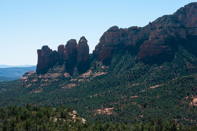
This is the part the Forest Service writes about with the most enthusiasm. The trail "begins right at the edge of the town of Sedona and is as picturesque as it is convenient," and it "leads you right out into the open." Its advice: "Bring along a map to help you identify Coffee Pot Rock, Wilson Mountain, Chimney Rock and more." That's a useful way to approach the hike. Brins Mesa isn't built around a single landmark you walk to and photograph. The reward is the open view in several directions once you're up top, and the fun of naming the formations around you. A paper map or an offline map on your phone helps with both. We don't describe the vegetation history of the mesa, and we don't print stories about how the landscape got its current look. If that history matters to you, ask at the Red Rock Ranger Visitor Center, which the Forest Service lists as the office contact for this trail.
Heat, shade and time of day
The Forest Service's own words are the best guide here: "The hike is not too steep and not too long, but it can be a bit hot during summer. No matter, you'll be glad you braved the heat when you see the views." The same feature that makes Brins Mesa popular, open ground with long views, means there's little to hide under. What we'd suggest, softly: Start early in warm months. Open trails heat up fast, and the Forest Service time of 1 hour 45 mins is one way. Carry more water than you think you need, and turn around at the halfway point of your water, not the halfway point of the trail. Have a cooler plan B. Our cool things to do on a hot day in Sedona guide has ideas that don't involve a long exposed hike. Pick your season. Our best time to visit Sedona guide covers seasons, heat and crowds across the year. We don't publish sunrise or sunset times for the trail, shade percentages, or a "best hour." Nobody we can cite measures them.
Wilderness rules on the mesa
Brins Mesa Trail sits in the Forest Service's Red Rock–Secret Mountain Wilderness recreation group, and the trail page prints one restriction: "No mechanized vehicles (including mountain bikes) in Wilderness." Leave the bike at home for this one. The Forest Service lists horseback riding among the recreation opportunities on the trail page, so you may share the trail with riders. The page doesn't print a dog rule, and we don't borrow one from elsewhere. If you're bringing a dog, check with the Red Rock Ranger Visitor Center first. The usual rules apply: stay on the trail, pack out what you bring in, and leave the mesa the way you found it.
Current notices
We read the Coconino National Forest alerts page (https://www.fs.usda.gov/r03/coconino/alerts) on October 9, 2026. It listed no alert naming Brins Mesa, Jim Thompson or Jordan Road. Sedona-area items on the list that day included a "West Fork Temporary Area Closure - Extended" (alert start date September 26, 2026) and "West Sedona Camping and Campfire Restrictions" (alert start date August 31, 2026). The fire danger status for the Red Rock Ranger District showed Low. That was one reading on one morning. Alerts change, so check the alerts page the day you go, and if anything on the ground is signed, fenced or closed, respect it.
Brins Mesa or Soldier Pass?
If you have time for one hike and you're choosing between the two, here is a comparison using only what the Forest Service pages publish (read October 9, 2026). Forest Service difficulty — Brins Mesa (Trail No. 119): Easy to moderate; Soldier Pass (Trail No. 66): Moderate. Length, as published — Brins Mesa (Trail No. 119): 3.5 miles one way; Soldier Pass (Trail No. 66): 4 miles roundtrip in the table (the prose also says 4.5). Elevation gain — Brins Mesa (Trail No. 119): 649 ft; Soldier Pass (Trail No. 66): 641 ft. Time, as published — Brins Mesa (Trail No. 119): 1 hour 45 mins one way; Soldier Pass (Trail No. 66): 2.5 hours roundtrip. Parking — Brins Mesa (Trail No. 119): Jim Thompson: Red Rock Pass or America the Beautiful; Soldier Pass (Trail No. 66): Its own access rules and calendar. See Soldier Pass Sedona. Feel — Brins Mesa (Trail No. 119): Open views from the start, "not too steep and not too long"; Soldier Pass (Trail No. 66): Several named stops early on, then "increasingly steep and rocky" to the pass. Brins Mesa suits people who want a steady, open walk with big views and a simpler parking story. Soldier Pass packs its famous stops into the first stretch and has a more complicated access calendar. Neither is a lesser hike. They're different days, and they happen to meet on the same mesa.
What about the shuttle?
We don't claim that any shuttle serves Brins Mesa or the Jim Thompson Trailhead. Our Sedona Shuttle record (compiled September 26, 2026, from the City's how-to-ride page) lists the five trailheads the free fixed-route service serves: Cathedral Rock, Little Horse, Soldier Pass, Dry Creek Vista (with access to Devil's Bridge) and Mescal. Brins Mesa and Jim Thompson aren't on that list. Check the City's own page for current days and hours before you plan around it.
If you want a different shape of day
These are other options, not a ranking. A short, steep climb with a famous view: Cathedral Rock Sedona. Easy, family-friendly red-rock walking: Bell Rock Pathway Sedona. A view you can drive to: Airport Mesa Sedona. Another busy icon, with timing advice: When to hike Devil's Bridge in Sedona. Creek-level views of Cathedral Rock: Crescent Moon / Red Rock Crossing Sedona. This uses a different fee system from Jim Thompson. If you'd like someone else to lead: Sedona guided hikes, compared. Every trail record in the Index: Sedona trails. Fitting it into a trip: Plan a Sedona trip covers how many days to allow and what to book first.
Before you go
1. Read the Forest Service page. Brins Mesa Trail No. 119 is Easy to moderate: 3.5 miles one way, 649 ft of gain, and 1 hour 45 mins one way as published. Read the Brins Mesa Trail No. 119 page (https://www.fs.usda.gov/r03/coconino/recreation/trails/brins-mesa-trail-no-119) the week you go. 2. Pick your end. Jim Thompson off Jordan Road is passable by passenger cars per the Forest Service. The FR 152 end needs a high-clearance vehicle or a 2.24-mile road walk. 3. Bring a Red Rock Pass or an America the Beautiful pass for Jim Thompson. Prices and how to buy are on our Red Rock Pass guide. 4. Check alerts on the Coconino National Forest alerts page (https://www.fs.usda.gov/r03/coconino/alerts) the morning you go. 5. Plan for sun. Start early in warm months, carry plenty of water, and have a backup plan. 6. Leave the bike behind. No mechanized vehicles, mountain bikes included, in Wilderness. 7. Thinking about Soldier Pass too? Start with our Soldier Pass Sedona guide. 8. For the short record, see Brins Mesa Trail No. 119.
What this page will not say
This page doesn't give loop mileage, loop times or turn-by-turn loop directions. It doesn't claim any shuttle serves Brins Mesa or the Jim Thompson Trailhead. It doesn't publish lot counts, fill times, wait times, roadside-parking rules, fines, walking minutes from town, or any pace or mileage the Forest Service doesn't print. It doesn't say whether a pass is needed at the FR 152 end, because the pages we read don't say. It doesn't print pass prices, which are on the Red Rock Pass guide. It doesn't tell the mesa's fire or vegetation history. It doesn't name tour companies, hotels or restaurants. If the Forest Service pages change, trust those pages. Spot something wrong or out of date? Corrections are free and need no account: report an error.
About this page
This guide sticks to what official pages publish. It doesn't give loop mileage, parking counts, fill times or shuttle stops. Check the Forest Service Brins Mesa Trail No. 119 page (https://www.fs.usda.gov/r03/coconino/recreation/trails/brins-mesa-trail-no-119) before you go, and turn back whenever the heat or the trail stops feeling right. This page is not a fitness or medical receipt. Brins Mesa is an easy-to-moderate climb onto an open mesa, on a trail that begins "right at the edge of the town of Sedona." The Forest Service publishes Brins Mesa Trail No. 119 as 3.5 miles one way with 649 ft of elevation gain, rated Easy to moderate, and times it at 1 hour 45 mins one way (read October 9, 2026). Many hikers start from the Jim Thompson Trailhead off Jordan Road (the Forest Service calls it "an alternate approach"), where a Red Rock Pass or America the Beautiful Pass is required to park. Brins Mesa also meets Soldier Pass Trail up on the mesa, which is why so many people ask about combining the two. Our Soldier Pass Sedona guide covers that side. The Forest Service sums up the appeal in one line: instead of keeping you "tucked away in a deep canyon or clinging to the side of a steep slope," this trail "leads you right out into the open where you can enjoy unobstructed views of the spectacular red rock formations." It also gives the honest caveat: "The hike is not too steep and not too long, but it can be a bit hot during summer." The dated count this page can honestly print is the trail records this index already holds: As of October 9, 2026 that is 24 trail records and 5 hiking tour records. The comparison pages below are the lists.
What this index currently holds
- Trails
- 24 trail recordsChecked via: Count of compiled, non-sample records in this index
- as of October 9, 2026
- Hiking tour
- 5 hiking tour recordsChecked via: Count of compiled, non-sample records in this index
- as of October 9, 2026
- Last reviewed
- October 9, 2026
- as of October 9, 2026
Related reading
More long-form answers and the comparison pages this page points at. Figures on those pages come from the records, not from this map. The full shelf is on guides; the compact list is on traveller questions.
Guide
Soldier Pass Sedona (Trail No. 66)
Soldier Pass (USFS Trail No. 66) is a moderate hike with Devil’s Kitchen, Seven Sacred Pools, and an optional arch spur. Two ways in: gated USFS lot when open, or free Sedona Shuttle Route 14 when shuttles run. Confirm USFS and Route 14 live.
Last reviewed October 5, 2026.
Guide
Red Rock Pass Sedona
A Red Rock Pass covers parking at designated Coconino National Forest fee sites around Sedona. America the Beautiful works in lieu at many of those. Neither covers Coconino Hospitality sites (Crescent Moon, West Fork, Grasshopper Point) or Arizona State Parks. Dated FS fees with links to the official pages.
Last reviewed October 5, 2026.
Guide
Cool things to do on a hot day in Sedona, Arizona
What to do when Sedona is hot: walk early, then spend the afternoon indoors or in a seat. Counts from this index — trails, jeep and trolley tours, restaurants, coffee, chocolate, tasting rooms, yoga and day spas — dated, not ranked.
Last reviewed September 13, 2026.
Guide
Best time to visit Sedona
Best time to visit Sedona depends on the priority: spring or fall for hiking comfort and more crowds, or winter chill and summer heat with a dawn plan for quieter days. Weekdays beat weekends; peak lots fill early. No climate normals, lodging rates, or festival dates.
Last reviewed October 9, 2026.
Guide
Cathedral Rock Sedona (Trail No. 170)
Cathedral Rock is a short, strenuous scramble (USFS: more rock climb than hike). Two ways in: private Back O’ Beyond lot when open (RRP or ATB), or free Sedona Shuttle Route 15 when trailhead shuttles run. Confirm USFS and Route 15 live.
Last reviewed October 5, 2026.
Guide
Bell Rock Pathway Sedona (Trail No. 96)
Bell Rock Pathway (USFS Trail No. 96) is an Easy family-friendly SR 179 corridor with red-rock views without climbing the formation. Private multi-lot parking (RRP or ATB); not a trailhead-shuttle stop. Check USFS and pass details before you go.
Last reviewed October 9, 2026.
Guide
Airport Mesa / Airport Scenic Overlook / Airport Loop (Sedona)
Airport Mesa is three stops: the drive-up Scenic Overlook, a short vortex/mesa walk, and Airport Loop Trail No. 210. Overlook parking is not a Red Rock Pass or America the Beautiful. Prefer USFS 3.5 mi for the loop; check overlook fees before you go.
Last reviewed October 16, 2026.
Guide
When to Hike Devil’s Bridge in Sedona
Devil’s Bridge is one hike with three access routes plus a shuttle option. Decide vehicle clearance and day-of-week first; confirm USFS and Route 11 live.
Last reviewed October 5, 2026.
Guide
Crescent Moon / Red Rock Crossing Sedona
Crescent Moon Picnic Site (Red Rock Crossing) is the Forest Service day-use area for the classic Cathedral Rock reflection in Oak Creek — picnic, wade, swim, creek-level views. Entrance is Coconino Hospitality, not a Red Rock Pass or America the Beautiful. Confirm hours and fees on the USFS page.
Last reviewed October 5, 2026.
Compare
Sedona guided hikes
Sedona guided hiking tours compared: per-person starting prices, group-size pricing, meeting points and Forest Service permit statements, straight from each operator's own site, dated.
Last reviewed September 26, 2026.
Compare
Plan a Sedona trip
Plan a Sedona trip: 2 days for an overview plus a hike or jeep, 3 if you add Grand Canyon. Red Rock Pass, stay zones, what to book first, and dated jeep and trolley listings. No booking, no ranking.
Last reviewed October 9, 2026.
Report an error
Found something wrong or out of date? Tell us and we will check it. It is free, there is no account, and you do not have to be the business owner. Corrections go to Thomas Karl at thomas@sedonatechsolutions.com.
Email a correction about Brins Mesa, Sedona
Opens your email app with the page and a few prompts already filled in. Prefer to write it yourself? Write to thomas@sedonatechsolutions.com directly.